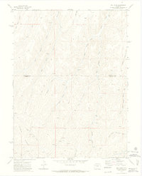
1971 Map of Bull Fork
USGS Topo · Published 1974About this map
Puddin Ridge and a complex network of steep gulches define this 1970s landscape along the border of Rio Blanco and Garfield counties. The terrain is marked by the drainages of Bull Fork, Hunter Creek, and Willow Creek, which feed southward toward Parachute Creek. This high-country region shows little in the way of permanent settlement, instead reflecting an economy of resource exploration and seasonal access. Numerous Drill Holes and Prospects are scattered across the slopes, particularly near Whiskey Gulch and Stewart Gulch, indicating the active mineral and energy interests of the era. A web of Jeep Trails and unnamed Trails provides the primary means of navigation through the deep incisions of Enoch Gulch and Little Dry Gulch.
Find a feature on this map
21 named features on this map. Tap any name to fly to it.
Don’t see what you’re looking for? This feature index may not catch every label — zoom into the map to look around manually.
Map Details
Editions of this 1971 Bull Fork Map
3 editions found
Other maps of this area

1925 · Parachute Creek
USGS Topo · 1:62,500

1927 · Parachute Creek
USGS Topo · 1:62,500

1929 · Highmore
USGS Topo · 1:62,500

1952 · Yankee Gulch
USGS Topo · 1:24,000

1952 · Rock School
USGS Topo · 1:24,000

1952 · Jessup Gulch
USGS Topo · 1:24,000

1956 · Grand Junction
USGS Topo · 1:250,000

1959 · Grand Junction
USGS Topo · 1:250,000

1960 · Grand Junction
USGS Topo · 1:250,000

1962 · Grand Junction
USGS Topo · 1:250,000