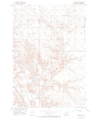
1956 Map of Bullhead
USGS Topo · Published 1974About this map
Bullhead sits prominently on a bend of the Grand River in Corson County, established as part of the Department of the Interior's Missouri River Basin development program. The settlement serves as the primary focal point of this mid-century survey, surrounded by a complex network of prairie drainage. To the north, the high ground is defined by the flat-topped ridges of Walker and Cadillac, separated by the winding course of Rock Creek. These uplands descend into a series of deeply eroded draws and creeks, including Stink Creek and Dog Creek, which feed into the main river channel. The map provides a detailed view of the regional topography and early infrastructure before further modernization, documenting the relationship between the isolated community and its intricate fluvial landscape.
Find a feature on this map
7 named features on this map. Tap any name to fly to it.
Don’t see what you’re looking for? This feature index may not catch every label — zoom into the map to look around manually.
Map Details
Editions of this 1956 Bullhead Map
3 editions found
Other maps of this area

1953 · McIntosh
USGS Topo · 1:250,000

1956 · Bullhead
USGS Topo · 1:24,000

1956 · Little Eagle NW
USGS Topo · 1:24,000

1956 · Miscol
USGS Topo · 1:24,000

1956 · Bullhead SW
USGS Topo · 1:24,000

1956 · Miscol NE
USGS Topo · 1:24,000

1958 · McIntosh
USGS Topo · 1:250,000

1971 · McLaughlin SW
USGS Topo · 1:24,000
1971 · Maple Leaf
USGS Topo · 1:24,000

1972 · Walker
USGS Topo · 1:24,000