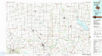
1985 Map of Burkburnett
USGS Topo · Published 1991About this map
The Red River carves the winding boundary between Oklahoma and Texas in this mid-1980s landscape, a region defined by extensive Oil Field operations and a robust transportation network. Centered on Burkburnett, the map documents a transition from the industrial energy zones of North Texas to the agricultural plains of Southwest Oklahoma. The infrastructure of the era is prominent, featuring the H.E. Bailey Turnpike and multiple rail lines including the Burlington Northern and the Chicago Rock Island and Pacific.
Find a feature on this map
55 named features on this map. Tap any name to fly to it.
Don’t see what you’re looking for? This feature index may not catch every label — zoom into the map to look around manually.
Map Details
Editions of this 1985 Burkburnett Map
2 editions found

Other maps of this area

1901 · Addington
USGS Topo · 1:125,000

1902 · Rush Springs
USGS Topo · 1:125,000

1905 · Montague
USGS Topo · 1:125,000

1915 · Clara
USGS Topo · 1:24,000

1915 · Barwise School
USGS Topo · 1:24,000

1915 · Burkburnett
USGS Topo · 1:24,000

1916 · Electra
USGS Topo · 1:24,000

1916 · Iowa Park
USGS Topo · 1:24,000

1916 · Fowlkes
USGS Topo · 1:24,000

1917 · Beaver Creek
USGS Topo · 1:24,000