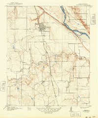
1918 Map of Burkburnett
USGS Topo · Published 1949About this map
The town of Burkburnett stands as the central hub of this North Texas survey, positioned just south of the winding Red River that defines the border between Texas and Oklahoma. The landscape is a network of early regional transportation, anchored by the Wichita and Northwestern rail line and the Wichita Falls Road. These corridors reveal the 1915 settlement patterns of Wichita County, where land was subdivided into a regular grid of sections. To the southeast, the Cashion School represents the rural educational foundations of the era, while the drainage of Gilbert Creek cuts westward through the terrain. The presence of the Electra Road further emphasizes the connection between this growing community and the surrounding oil and agricultural lands of the Red River valley during the early twentieth century.
Find a feature on this map
9 named features on this map. Tap any name to fly to it.
Don’t see what you’re looking for? This feature index may not catch every label — zoom into the map to look around manually.
Map Details
Editions of this 1918 Burkburnett Map
3 editions found
Other maps of this area

1915 · Clara
USGS Topo · 1:24,000

1915 · Burkburnett
USGS Topo · 1:24,000

1916 · Iowa Park
USGS Topo · 1:24,000

1918 · Buckburnett
USGS Topo · 1:31,680

1918 · Clara
USGS Topo · 1:31,680

1918 · Iowa Park
USGS Topo · 1:31,680

1954 · Wichita Falls
USGS Topo · 1:250,000

1955 · Lawton
USGS Topo · 1:250,000

1957 · Wichita Falls West
USGS Topo · 1:24,000

1957 · Burkburnett
USGS Topo · 1:62,500