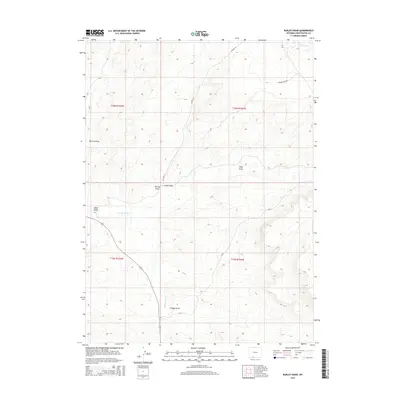
2015 Map of Burley Draw
USGS Topo · Published 2015About this map
Burley Draw and the surrounding drainage systems of the Wyoming high desert are the focus of this 2015 survey. This area of Sweetwater County is characterized by a complex network of seasonal watercourses and topographic depressions, including Polly Draw, Cedar Draw, and the wide Big Flat Draw. The map documents the way water moves across this arid landscape toward Black Butte Cr in the north and through E Salt Wells Cr in the west. Human presence is defined primarily by the section lines of the Public Land Survey System and a few established tracks like Brady Field Rd and Co Road 24. Features like Scheggs Draw and Alkali Wash illustrate the alkaline and erosive nature of the terrain, while the contour detail reveals the subtle ridges and plateaus that define the basin geography.
Find a feature on this map
15 named features on this map. Tap any name to fly to it.
Don’t see what you’re looking for? This feature index may not catch every label — zoom into the map to look around manually.
Map Details
Editions of this 2015 Burley Draw Map
This is the sole edition of this map. No revisions or reprints were ever made.
Other maps of this area

1954 · Rock Springs
USGS Topo · 1:250,000

1958 · Rock Springs
USGS Topo · 1:250,000

1962 · Rock Springs
USGS Topo · 1:250,000
1963 · Potter Mountain
USGS Topo · 1:24,000

1963 · Erickson-Kent Ranch
USGS Topo · 1:24,000

1968 · Cooper Ridge NE
USGS Topo · 1:24,000

1968 · Sand Butte Rim NW
USGS Topo · 1:24,000

1968 · Mud Springs Ranch
USGS Topo · 1:24,000

1968 · Pine Butte
USGS Topo · 1:24,000

1968 · Camel Rock
USGS Topo · 1:24,000