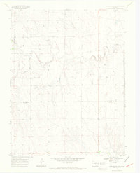
1969 Map of Burlington 3 SE
USGS Topo · Published 1972About this map
The high plains landscape of eastern Colorado is defined by the winding course of the North Fork Smoky Hill River as it moves across the boundary of Kit Carson Co and Cheyenne Co. This 1969 survey captures a rural area characterized by its wide drainage patterns and scattered water resources. Numerous locations marked simply as Well indicate the critical importance of groundwater for agriculture and livestock in this semi-arid region. The map also documents a network of fence lines, noted in the margin as fine red dashed lines, which reveal the structured division of the land into large sections typical of the Western range. While no major towns appear on this specific sheet, the topographic detail provides a precise record of the local hydrology and the subtle elevation changes that directed early settlement and grazing patterns.
Find a feature on this map
3 named features on this map. Tap any name to fly to it.
Don’t see what you’re looking for? This feature index may not catch every label — zoom into the map to look around manually.
Map Details
Editions of this 1969 Burlington 3 SE Map
5 editions found
Other maps of this area

1892 · Cheyenne Wells
USGS Topo · 1:125,000

1894 · Cheyenne Wells
USGS Topo · 1:125,000

1954 · Limon
USGS Topo · 1:250,000

1954 · Lamar
USGS Topo · 1:250,000

1957 · Limon
USGS Topo · 1:250,000

1958 · Limon
USGS Topo · 1:250,000

1958 · Lamar
USGS Topo · 1:250,000

1969 · Mount Sunflower SW
USGS Topo · 1:24,000

1969 · Burlington 3 SE
USGS Topo · 1:24,000

1969 · Mount Sunflower NW
USGS Topo · 1:24,000