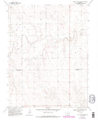
1969 Map of East Of Rock Creek
USGS Topo · Published 1995About this map
The North Fork Smoky Hill River meanders across this High Plains landscape, carving a distinct drainage pattern through the arid terrain of eastern Colorado. This late 1960s survey, updated with mid-1980s data, illustrates a region defined by agricultural utility and resource extraction. Numerous wells are scattered throughout the sections, indicating the importance of subterranean water or mineral rights in this high-altitude prairie environment. The map documents the political boundary between Kit Carson Co and Cheyenne Co, providing a clear record of land division and ownership patterns for the era. A prominent Pipeline traverses the southern portion of the quadrangle, reflecting the infrastructure required to move resources across this open country.
Find a feature on this map
4 named features on this map. Tap any name to fly to it.
Don’t see what you’re looking for? This feature index may not catch every label — zoom into the map to look around manually.
Map Details
Editions of this 1969 East Of Rock Creek Map
5 editions found
Other maps of this area

1892 · Cheyenne Wells
USGS Topo · 1:125,000

1894 · Cheyenne Wells
USGS Topo · 1:125,000

1954 · Limon
USGS Topo · 1:250,000

1954 · Lamar
USGS Topo · 1:250,000

1957 · Limon
USGS Topo · 1:250,000

1958 · Limon
USGS Topo · 1:250,000

1958 · Lamar
USGS Topo · 1:250,000

1969 · Mount Sunflower SW
USGS Topo · 1:24,000

1969 · Burlington 3 SE
USGS Topo · 1:24,000

1969 · Mount Sunflower NW
USGS Topo · 1:24,000