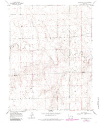
1969 Map of Burlington 3 Se
USGS Topo · Published 1985About this map
The North Fork Smoky Hill River carves a distinctive path across this High Plains landscape, where the geography is defined by a series of intermittent drainage systems and scattered water sources. In a region where water availability dictated land use, numerous labels for Well and specific landmarks like Windrift Ranch point to the agricultural and ranching operations that sustained local families. The map also delineates the high-plains transition between Kit Carson and Cheyenne Counties, providing a clear view of the rural boundary lines established as the cattle industry and dryland farming shaped the eastern Colorado frontier. Tracing the courses of Cow Creek and Rock Creek, researchers can see the natural topography that influenced the placement of early fence lines and homesteads throughout the late twentieth century.
Find a feature on this map
7 named features on this map. Tap any name to fly to it.
Don’t see what you’re looking for? This feature index may not catch every label — zoom into the map to look around manually.
Map Details
Editions of this 1969 Burlington 3 Se Map
5 editions found
Other maps of this area

1892 · Cheyenne Wells
USGS Topo · 1:125,000

1894 · Cheyenne Wells
USGS Topo · 1:125,000

1954 · Limon
USGS Topo · 1:250,000

1954 · Lamar
USGS Topo · 1:250,000

1957 · Limon
USGS Topo · 1:250,000

1958 · Limon
USGS Topo · 1:250,000

1958 · Lamar
USGS Topo · 1:250,000

1969 · Mount Sunflower SW
USGS Topo · 1:24,000

1969 · Burlington 3 SE
USGS Topo · 1:24,000

1969 · Mount Sunflower NW
USGS Topo · 1:24,000