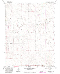
1969 Map of Burlington 3 Se
USGS Topo · Published 1985About this map
The North Fork Smoky Hill River meanders across this High Plains landscape, marking a significant drainage route in the eastern Colorado territory. This 1969 survey, later updated with mid-1980s data, documents the sparsely populated border region between Kit Carson Co and Cheyenne Co. The terrain is defined by a heavy concentration of several dozen industrial Well sites, reflecting the intensive subsurface exploration of the era. A prominent Pipeline cuts through the southern portion of the map, illustrating the infrastructure required to transport resources from these remote fields to larger distribution networks. Beyond the river and its tributaries, the map reveals a meticulously surveyed grid of land sections typical of the western plains, where ranching and resource extraction coexist.
Find a feature on this map
4 named features on this map. Tap any name to fly to it.
Don’t see what you’re looking for? This feature index may not catch every label — zoom into the map to look around manually.
Map Details
Editions of this 1969 Burlington 3 Se Map
5 editions found
Other maps of this area

1892 · Cheyenne Wells
USGS Topo · 1:125,000

1894 · Cheyenne Wells
USGS Topo · 1:125,000

1954 · Limon
USGS Topo · 1:250,000

1954 · Lamar
USGS Topo · 1:250,000

1957 · Limon
USGS Topo · 1:250,000

1958 · Limon
USGS Topo · 1:250,000

1958 · Lamar
USGS Topo · 1:250,000

1969 · Mount Sunflower SW
USGS Topo · 1:24,000

1969 · Burlington 3 SE
USGS Topo · 1:24,000

1969 · Mount Sunflower NW
USGS Topo · 1:24,000