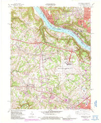
1983 Map of Burlington
USGS Topo · Published 1987About this map
The Ohio River forms the central spine of this mid-1980s landscape, marking the jagged boundary between Hamilton County, Ohio, and Boone County, Kentucky. This era shows the massive footprint of the Greater Cincinnati International Airport dominating the Kentucky side, surrounded by evolving suburban settlements like Hebron and Burlington. Local history is preserved in small details, such as the Col Abraham Depew Grave near the riverbanks and family burial grounds like Chambers Cem and Aylor Cem.
Find a feature on this map
58 named features on this map. Tap any name to fly to it.
Don’t see what you’re looking for? This feature index may not catch every label — zoom into the map to look around manually.
Map Details
Editions of this 1983 Burlington Map
4 editions found
Other maps of this area

1914 · West Cincinnati
USGS Topo · 1:62,500

1915 · Lawrenceburg
USGS Topo · 1:48,000

1928 · Lawrenceburg
USGS Topo · 1:62,500

1932 · Lawrenceburg
USGS Topo · 1:62,500

1943 · Rising Sun
USGS Topo · 1:24,000

1943 · Hooven
USGS Topo · 1:24,000

1943 · Lawrenceburg
USGS Topo · 1:24,000

1950 · Union
USGS Topo · 1:24,000

1950 · Independence
USGS Topo · 1:24,000

1950 · Covington
USGS Topo · 1:24,000