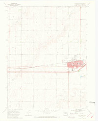
1969 Map of Burlington
USGS Topo · Published 1972About this map
Burlington is mapped here as a developing hub of Kit Carson County, organized around the Chicago Rock Island and Pacific railroad and the adjacent corridor of West Burlington. The town's civic character is defined by its concentrated infrastructure, including the Burlington Rodeo Ground, a Municipal Airport, and the High Sch. The landscape is etched by several seasonal watercourses such as Bonny Creek, Beaver Creek, and Sand Creek, which cut through the high plains terrain. Beyond the residential grid of streets like Lowell Ave and Rose Ave, the map reveals the local economy through scattered Gravel Pits and agricultural features. This survey preserves the exact layout of the community before later interstate expansion further altered the traditional rail-oriented footprint of the town.
Find a feature on this map
22 named features on this map. Tap any name to fly to it.
Don’t see what you’re looking for? This feature index may not catch every label — zoom into the map to look around manually.
Map Details
Editions of this 1969 Burlington Map
3 editions found
Other maps of this area

1954 · Limon
USGS Topo · 1:250,000

1957 · Limon
USGS Topo · 1:250,000

1958 · Limon
USGS Topo · 1:250,000

1969 · Settlement
USGS Topo · 1:24,000

1969 · Bethune
USGS Topo · 1:24,000

1969 · Burlington
USGS Topo · 1:24,000

1969 · Mount Sunflower NW
USGS Topo · 1:24,000

1969 · Peconic
USGS Topo · 1:24,000

1969 · Kanorado NW
USGS Topo · 1:24,000

1969 · Burlington 3 NW
USGS Topo · 1:24,000