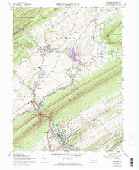
1966 Map of Burnham
USGS Topo · Published 1973About this map
Kishacoquillas Valley serves as the central corridor for this 1960s study, where the Penn Central rail line follows the winding course of Honey Creek and Kishacoquillas Creek. The industrial and residential development of Burnham and Yeagertown is prominent in the south, while the village of Milroy anchors the northern end of the valley. This period of the mid-twentieth century shows established local institutions like the Kishacoquillas High Sch and a Drive-in Theater, alongside several family and community burial grounds including Birch Hill Cem and Woodlawn Cem.
Find a feature on this map
77 named features on this map. Tap any name to fly to it.
Don’t see what you’re looking for? This feature index may not catch every label — zoom into the map to look around manually.
Map Details
Editions of this 1966 Burnham Map
Other maps of this area

1924 · Centre Hall
USGS Topo · 1:62,500

1924 · Lewistown
USGS Topo · 1:62,500

1925 · Mifflintown
USGS Topo · 1:48,000

1927 · Lewisburg
USGS Topo · 1:62,500

1929 · Centre Hall
USGS Topo · 1:62,500

1934 · Mifflintown
USGS Topo · 1:62,500

1937 · Mifflintown
USGS Topo · 1:62,500

1937 · Millheim
USGS Topo · 1:48,000

1941 · Millheim
USGS Topo · 1:62,500

1943 · Lewistown
USGS Topo · 1:125,000
Featured Places
- Granville Township, PA
- Decatur Township, PA
- Burnham, PA
- Highland Park, Derry Township
- Milroy, Armagh Township