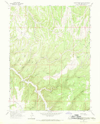
1966 Map of Burnt Timber Canyon
USGS Topo · Published 1970About this map
Boulevard Ridge and Atchee Ridge dominate this portion of Uintah County, Utah, where a complex network of high ridges and deep canyons defines the landscape. The drainage system is anchored by Bitter Creek and its many tributaries, including Center Fork Asphalt Wash and Burnt Timber Canyon. This mid-1960s survey reveals a largely unpopulated territory utilized for its natural resources and remote accessibility, evidenced by a solitary Drill Hole and an isolated Landing Strip on the high ground near Flat Rock Spring. The topography is etched with numerous named canyons such as Nelson Canyon, Buck Canyon, and Zane Canyon, alongside family-named landmarks like Brewer Ridge and Anderson Canyon. These features illustrate the area's history of mineral exploration and ranching, where reliable water sources like Indian Spring were critical for survival in the arid high-plateau environment.
Find a feature on this map
29 named features on this map. Tap any name to fly to it.
Don’t see what you’re looking for? This feature index may not catch every label — zoom into the map to look around manually.
Map Details
Editions of this 1966 Burnt Timber Canyon Map
2 editions found
Other maps of this area

1885 · East Tavaputs
USGS Topo · 1:250,000

1956 · Grand Junction
USGS Topo · 1:250,000

1959 · Grand Junction
USGS Topo · 1:250,000

1960 · Grand Junction
USGS Topo · 1:250,000

1962 · Grand Junction
USGS Topo · 1:250,000

1964 · Grand Junction
USGS Topo · 1:250,000

1965 · Grand Junction
USGS Topo · 1:250,000

1966 · Seep Canyon
USGS Topo · 1:24,000

1966 · Tom Patterson Canyon
USGS Topo · 1:24,000
1966 · Rat Hole Ridge
USGS Topo · 1:24,000