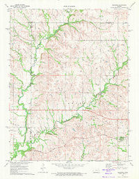
1971 Map of Bushong
USGS Topo · Published 1973About this map
The Missouri Pacific railroad corridor defines the southern landscape of this northern Lyon County region, connecting the small community of Bushong with the settlement at Comisky. This 1971 survey captures a quiet agricultural era where life centered around the rail line and the various creeks that drain the Kansas prairie. In the township of Agnes City, the local topography is shaped by Rock Creek, Bluff Creek, and Missouri Creek, which carve gentle valleys through the landscape. Genealogists can find important local landmarks such as Agnes City Cem and Comisky Cem, which serve as physical links to the families who settled this area. The map also delineates the jurisdictional boundaries where Morris and Lyon Counties meet, as well as the border with Wabaunsee County to the north, showing the intersecting lines of rural administration.
Find a feature on this map
13 named features on this map. Tap any name to fly to it.
Don’t see what you’re looking for? This feature index may not catch every label — zoom into the map to look around manually.
Map Details
Editions of this 1971 Bushong Map
2 editions found
Other maps of this area

1885 · Eskridge
USGS Topo · 1:125,000

1889 · Eskridge
USGS Topo · 1:125,000

1894 · Eskridge
USGS Topo · 1:125,000

1955 · Hutchinson
USGS Topo · 1:250,000

1959 · Hutchinson
USGS Topo · 1:250,000

1971 · Alta Vista SE
USGS Topo · 1:24,000

1971 · Allen
USGS Topo · 1:24,000

1971 · Bushong
USGS Topo · 1:24,000

1971 · Alta Vista
USGS Topo · 1:24,000
1971 · Lake Wabaunsee
USGS Topo · 1:24,000