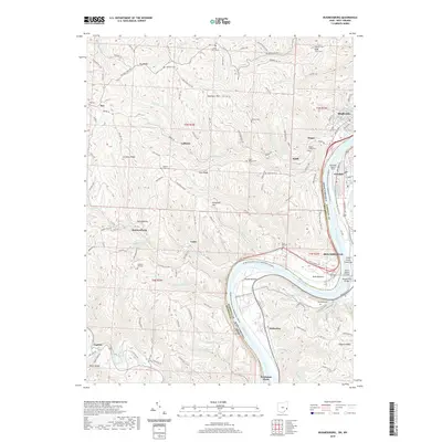
2019 Map of Businessburg
USGS Topo · Published 2019About this map
Ohio River barge traffic and industrial development anchor this section of the valley, where the state boundary separates Belmont County, Ohio, from Marshall County, West Virginia. The riverfront is dominated by logistics and transport, including CSX Transportation rail lines and the Arch A Moore Bridge connecting the shoreline communities. Along the eastern bank, the riverside towns of Moundsville and Glendale transition into the heights of Roberts Ridge, while the western side features the notable Round Bottom bend and the settlement of Dille Bottom. Genealogy researchers can find numerous upland burial sites like Dilles Bottom Cem and Upper Wegee Cem. The landscape is characterized by a series of deep drainages such as Wegee Cr and Pipe Cr that cut through ridges like Key Ridge and Crozier Ridge, illustrating the steep topography that has dictated local road networks and settlement patterns for generations.
Find a feature on this map
138 named features on this map. Tap any name to fly to it.
Don’t see what you’re looking for? This feature index may not catch every label — zoom into the map to look around manually.
Map Details
Editions of this 2019 Businessburg Map
This is the sole edition of this map. No revisions or reprints were ever made.
Other maps of this area

1902 · Wheeling
USGS Topo · 1:62,500

1904 · Cameron
USGS Topo · 1:62,500

1905 · Clarington
USGS Topo · 1:62,500

1905 · St. Clairsville
USGS Topo · 1:62,500

1935 · Cameron
USGS Topo · 1:62,500

1935 · Clarington
USGS Topo · 1:62,500

1935 · Wheeling
USGS Topo · 1:62,500

1940 · Clarington
USGS Topo · 1:62,500

1942 · Cameron
USGS Topo · 1:62,500

1942 · Wheeling
USGS Topo · 1:62,500