
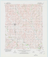
1957 Map of Butler
USGS Topo · Published 1958About this map
Butler and Stafford anchor this mid-century survey of western Oklahoma, where the landscape is defined by the winding course of the Washita River and its many tributaries. The area's social fabric is visible through a dense network of country institutions, including Prairie View Ch, Antioch Ch, and the Sunnyside Community Hall. The mapping reveals a rural economy supported by the Santa Fe railroad and local infrastructure such as an Oil Refinery and several pumping stations near the river.
Find a feature on this map
35 named features on this map. Tap any name to fly to it.
Don’t see what you’re looking for? This feature index may not catch every label — zoom into the map to look around manually.
Map Details
Editions of this 1957 Butler Map
2 editions found
Other maps of this area

1955 · Clinton
USGS Topo · 1:250,000

1956 · Cordell
USGS Topo · 1:62,500

1957 · Clinton
USGS Topo · 1:250,000

1957 · Clinton
USGS Topo · 1:62,500

1957 · Dill City
USGS Topo · 1:62,500

1960 · Hammon
USGS Topo · 1:62,500

1961 · Elk City
USGS Topo · 1:62,500

1961 · Leedey
USGS Topo · 1:62,500

1962 · Putnam
USGS Topo · 1:62,500

1962 · Aledo
USGS Topo · 1:62,500