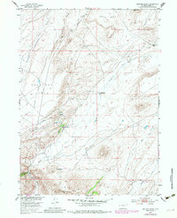
1953 Map of Buzzard Ranch
USGS Topo · Published 1983About this map
Buzzard Ranch serves as a central hub for livestock operations in this high-elevation landscape of Carbon County. The map details the ranching infrastructure necessary for survival and industry in the mid-20th century, including the Buzzard Ranch Shearing Pens and several critical water management features like the Buzzard Ditch. To the north, the small settlement of Gale sits near the headwaters of East Arkansas Creek, while the expansive Arkansas Flats spread toward the western boundary. The terrain is defined by dramatic elevation changes, rising from the Sand Creek Canyon floor to the high summit of Bear Mountain in the south. Local property markers like Roberts Ranch (Allen) and the Burtch Ranch offer specific points of interest for genealogists tracing family land holdings in the Missouri River Basin during this era of post-war development.
Find a feature on this map
22 named features on this map. Tap any name to fly to it.
Don’t see what you’re looking for? This feature index may not catch every label — zoom into the map to look around manually.
Map Details
Editions of this 1953 Buzzard Ranch Map
3 editions found
Other maps of this area

1951 · Pathfinder Reservoir NW
USGS Topo · 1:24,000

1951 · Independence Rock
USGS Topo · 1:24,000

1951 · Fort Ridge
USGS Topo · 1:24,000

1953 · Bradley Peak
USGS Topo · 1:24,000

1953 · Seminoe Dam
USGS Topo · 1:24,000

1953 · Ferris
USGS Topo · 1:24,000

1953 · Pathfinder Reservoir SW
USGS Topo · 1:24,000

1953 · Buzzard Ranch
USGS Topo · 1:24,000

1953 · Spanish Mine
USGS Topo · 1:24,000

1955 · Casper
USGS Topo · 1:250,000