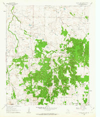
1960 Map of Buzzard Roost Knob
USGS Topo · Published 1963About this map
Buzzard Roost Knob dominates the central topography of this Montague County landscape as recorded in the early 1960s. The area is characterized by a network of drainage systems, including East Belknap Creek, Victoria Creek, and Polecat Creek, which carve through a terrain marked by distinctive elevations like Red Mound and Colt Mtn. This period captures a rural infrastructure focused on agriculture and education, evidenced by the presence of the Texas Agricultural Experimental Station and localized schools such as Rock Spring Sch and Lone Star Sch.
Find a feature on this map
13 named features on this map. Tap any name to fly to it.
Don’t see what you’re looking for? This feature index may not catch every label — zoom into the map to look around manually.
Map Details
Editions of this 1960 Buzzard Roost Knob Map
2 editions found
Other maps of this area

1905 · Montague
USGS Topo · 1:125,000

1954 · Sherman
USGS Topo · 1:250,000

1958 · Sherman
USGS Topo · 1:250,000

1960 · Buzzard Roost Knob
USGS Topo · 1:24,000

1961 · Stoneburg
USGS Topo · 1:24,000

1961 · Salona
USGS Topo · 1:24,000

1961 · Brushy Mound
USGS Topo · 1:24,000

1961 · Montague
USGS Topo · 1:24,000

1961 · Bowie
USGS Topo · 1:24,000

1968 · Nocona
USGS Topo · 1:24,000