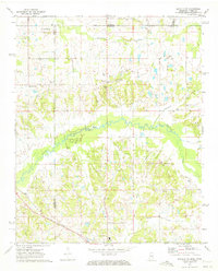
1971 Map of Byhalia NW
USGS Topo · Published 1973About this map
The Tennessee Mississippi Line cuts through this 1971 survey of Marshall and De Soto counties, where the rural landscape of the Deep South meets the advancing edge of suburban Memphis. The northern reaches are characterized by family-named landmarks and local hubs like Barton and Handy Corner, while the Colonial Landing Strip indicates the area's increasing accessibility. Much of the southern terrain is defined by the winding course of the Coldwater River and its tributaries, including Nonconnah Creek and Byhalia Creek. Numerous small congregational anchors such as Halliburton Ch, Shiloh Ch, and Mt Carmel Ch are scattered across the quadrangle, often adjacent to family burial sites like McGehee Cem. The presence of several Gravel Pits and a Shale Pit near the St Louis San Francisco railroad suggests an economy rooted in both the extraction of natural resources and the transport of goods along the rail corridor.
Find a feature on this map
38 named features on this map. Tap any name to fly to it.
Don’t see what you’re looking for? This feature index may not catch every label — zoom into the map to look around manually.
Map Details
Editions of this 1971 Byhalia NW Map
2 editions found
Other maps of this area

1943 · Collierville
USGS Topo · 1:62,500

1944 · Hernando
USGS Topo · 1:62,500

1948 · Byhalia
USGS Topo · 1:62,500

1953 · Collierville
USGS Topo · 1:50,000

1956 · Blytheville
USGS Topo · 1:250,000

1956 · Tupelo
USGS Topo · 1:250,000

1958 · Tupelo
USGS Topo · 1:250,000

1959 · Blytheville
USGS Topo · 1:250,000

1960 · Bartlett
USGS Topo · 1:62,500

1961 · Bartlett
USGS Topo · 1:62,500