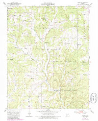
1950 Map of Cabool SW
USGS Topo · Published 1985About this map
Mountain Grove borders the northwestern edge of this survey, which captures a transitioning rural landscape in the Missouri Ozarks. The map documents a dense network of local education and faith centers that served the small agricultural communities of Clinton and Burdine. While active institutions like Union Chapel and Oak Grove Sch remain central to the community, the map also marks several sites as having already transitioned, such as Pleasant Hill Sch (Abandoned) and Lone Star Sch (Abandoned). The topography is defined by the winding North Fork River and its many tributaries, including Panther Creek and Little Creek. Much of the southern half falls within the protected boundaries of the Mark Twain National Forest, where steep drainages like Hungry Gulch and Creasy Hollow cut through the terrain. Notable local landmarks such as Onyx Cave and the Macedonia Cem provide specific points of interest for genealogists and local historians.
Find a feature on this map
34 named features on this map. Tap any name to fly to it.
Don’t see what you’re looking for? This feature index may not catch every label — zoom into the map to look around manually.
Map Details
Editions of this 1950 Cabool SW Map
3 editions found
Other maps of this area

1937 · Buckhart
USGS Topo · 1:48,000

1939 · Topaz
USGS Topo · 1:62,500

1941 · Topaz
USGS Topo · 1:62,500

1943 · Buckhart
USGS Topo · 1:62,500

1945 · Harrison
USGS Topo · 1:250,000

1945 · Buckhart
USGS Topo · 1:62,500

1949 · Harrison
USGS Topo · 1:250,000

1950 · Cabool SW
USGS Topo · 1:24,000

1951 · Mountain Grove South
USGS Topo · 1:24,000

1951 · Cabool SE
USGS Topo · 1:24,000