
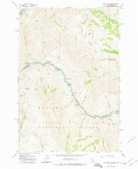
1963 Map of Cactus Mtn
USGS Topo · Published 1964About this map
The Snake River carves a deep boundary between Idaho and Oregon in this early 1960s survey, joined briefly in the north by the Salmon River. This high-relief terrain is part of the Wallowa-Whitman National Forest, where the Wallowa Summit Ridge towers over numerous canyons and gulches. Evidence of human activity is sparse but notable, centered on the river access at Dug Bar and the remote Spencer Ranch. Navigation of the river is marked by a series of treacherous water features, including Whitehorse Rapids, Zigzag Rapids, and Lower Dug Bar Rapids. A lone Landing Strip and a scattering of jeep trails underscore the isolation of this interior mountain landscape, while the Cow Creek Bridge provides a vital link across the lower drainages. The map serves as a detailed record of the confluence of state lines and the challenging topography of the Pacific Northwest river systems.
Find a feature on this map
58 named features on this map. Tap any name to fly to it.
Don’t see what you’re looking for? This feature index may not catch every label — zoom into the map to look around manually.
Map Details
Editions of this 1963 Cactus Mtn Map
2 editions found
Other maps of this area

1954 · Imnaha
USGS Topo · 1:62,500

1954 · Kernan Point
USGS Topo · 1:62,500

1955 · Grangeville
USGS Topo · 1:250,000

1959 · Grangeville
USGS Topo · 1:250,000

1963 · Deadhorse Ridge
USGS Topo · 1:24,000

1963 · Boles
USGS Topo · 1:24,000

1963 · Rattlesnake Ridge
USGS Topo · 1:24,000

1963 · Wapshilla Creek
USGS Topo · 1:24,000

1963 · Wolf Creek
USGS Topo · 1:24,000

1980 · Grangeville
USGS Topo · 1:100,000