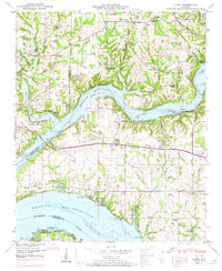
1950 Map of Cairo
USGS Topo · Published 1974About this map
The Tennessee River and Elk River dominate this portion of northern Alabama, where the creation of the Wheeler Reservoir fundamentally altered the riverine landscape. Rising waters gathered around prominent limestone features such as Buzzard Roost Bluff and Ivy Bluff, creating a complex shoreline that replaced older riverbanks. The map documents a rural transition as the region adjusted to the reservoir, with recreation areas like the Stewart Ferry Cabin Site Area appearing alongside long-established farming communities.
Find a feature on this map
81 named features on this map. Tap any name to fly to it.
Don’t see what you’re looking for? This feature index may not catch every label — zoom into the map to look around manually.
Map Details
Editions of this 1950 Cairo Map
4 editions found
Other maps of this area

1914 · Rogersville
USGS Topo · 1:48,000

1916 · Rogersville
USGS Topo · 1:62,500

1936 · Union Hill
USGS Topo · 1:24,000

1936 · Thorntontown
USGS Topo · 1:24,000

1936 · Stewart Cross Roads
USGS Topo · 1:24,000

1936 · Courtland
USGS Topo · 1:24,000

1936 · Lexington
USGS Topo · 1:24,000

1936 · Ripley
USGS Topo · 1:24,000

1936 · Hillsboro
USGS Topo · 1:24,000

1936 · Cairo
USGS Topo · 1:24,000
Featured Places
- Rogersville, AL
- Anderson Creek Estates, AL
- Anderson Creek Subdivision, AL
- Cave Spring, AL
- Coxey Creek Subdivision, AL