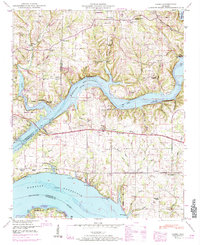
1950 Map of Cairo
USGS Topo · Published 1984About this map
The confluence of the Elk River and the Tennessee River dominates this mid-century landscape in Limestone County, shaped by the expansive waters of the Wheeler Reservoir. The map illustrates a rural society organized around small communities and numerous crossroads institutions, including Cairo, Lentzville, and Coxey. Cultural life is marked by a high density of local landmarks such as Mt Carmel Church, Little Elk Church, and Warner Chapel, alongside educational sites like the Clement Sch and Confluence School.
Find a feature on this map
67 named features on this map. Tap any name to fly to it.
Don’t see what you’re looking for? This feature index may not catch every label — zoom into the map to look around manually.
Map Details
Editions of this 1950 Cairo Map
4 editions found
Other maps of this area

1914 · Rogersville
USGS Topo · 1:48,000

1916 · Rogersville
USGS Topo · 1:62,500

1936 · Union Hill
USGS Topo · 1:24,000

1936 · Thorntontown
USGS Topo · 1:24,000

1936 · Stewart Cross Roads
USGS Topo · 1:24,000

1936 · Courtland
USGS Topo · 1:24,000

1936 · Lexington
USGS Topo · 1:24,000

1936 · Ripley
USGS Topo · 1:24,000

1936 · Hillsboro
USGS Topo · 1:24,000

1936 · Cairo
USGS Topo · 1:24,000
Featured Places
- Rogersville, AL
- Anderson Creek Estates, AL
- Anderson Creek Subdivision, AL
- Cave Spring, AL
- Coxey Creek Subdivision, AL