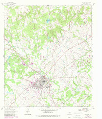
1961 Map of Caldwell
USGS Topo · Published 1989About this map
Caldwell serves as the focal point of this Burleson County survey, showing a well-established grid at the intersection of the Southern Pacific railroad and regional roadways. The landscape is heavily marked by the energy and extraction industries of the mid-20th century, with numerous Oil Wells and a prominent Pipeline cutting through the eastern sections. Just outside the main settlement, the community of Galilee and various family or community landmarks like Macedonia Cem and Oak Grove Cem provide essential data points for local genealogy.
Find a feature on this map
38 named features on this map. Tap any name to fly to it.
Don’t see what you’re looking for? This feature index may not catch every label — zoom into the map to look around manually.
Map Details
Editions of this 1961 Caldwell Map
2 editions found
Other maps of this area

1919 · Dime Box
USGS Topo · 1:62,500

1954 · Austin
USGS Topo · 1:250,000

1956 · Caldwell
USGS Topo · 1:62,500

1956 · Milano
USGS Topo · 1:62,500

1956 · Somerville
USGS Topo · 1:62,500

1960 · Lyons
USGS Topo · 1:24,000
1960 · Frenstat
USGS Topo · 1:24,000
1960 · Deanville
USGS Topo · 1:24,000
1961 · Caldwell
USGS Topo · 1:24,000

1961 · Mumford
USGS Topo · 1:24,000