
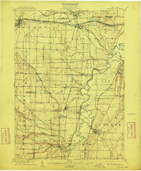
1904 Map of Caledonia
USGS Topo · Published 1904This historical map portrays the area of Caledonia in 1904, primarily covering Livingston County as well as portions of Monroe County, Wyoming County, and Genesee County. Featuring a scale of 1:62500, this map provides a highly detailed snapshot of the terrain, roads, buildings, counties, and historical landmarks in the Caledonia region at the time. Published in 1904, it is one of 6 known editions of this map due to revisions or reprints.
Find a feature on this map
60 named features on this map. Tap any name to fly to it.
Don’t see what you’re looking for? This feature index may not catch every label — zoom into the map to look around manually.
Map Details
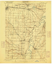
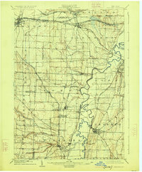
Editions of this 1904 Caledonia Map
6 editions found

Historical Maps of Simmons Corners Through Time
31 maps found

1902 Wayland
Livingston County, NY

1904 Caledonia
Livingston County, NY

1904 Wayland
Livingston County, NY

1905 Nunda
Livingston County, NY

1934 Rush
Livingston County, NY

1942 Conesus
Livingston County, NY

1942 Livonia
Livingston County, NY

1943 Mount Morris
Livingston County, NY

1943 Nunda
Livingston County, NY

1943 Ossian
Livingston County, NY

1943 Sonyea
Livingston County, NY

1944 Geneseo
Livingston County, NY

1944 Leicester
Livingston County, NY

1944 Mount Morris
Livingston County, NY

1944 Nunda
Livingston County, NY

1944 Ossian
Livingston County, NY

1944 Sonyea
Livingston County, NY

1950 Caledonia
Livingston County, NY

1950 Geneseo
Livingston County, NY

1951 Caledonia
Livingston County, NY

1951 Leicester
Livingston County, NY

1951 Livonia
Livingston County, NY

1951 Rush
Livingston County, NY

1957 Conesus
Livingston County, NY

1964 Conesus
Livingston County, NY

1971 Rush
Livingston County, NY

1972 Mount Morris
Livingston County, NY

1972 Nunda
Livingston County, NY

1972 Ossian
Livingston County, NY

1972 Sonyea
Livingston County, NY

1983 Canandaigua
Livingston County, NY