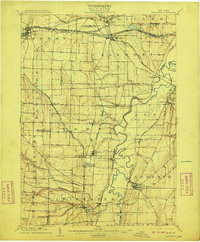
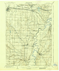
1904 Map of Caledonia
USGS Topo · Published 1909About this map
The Genesee River snakes through this 1902 survey of western New York, defining the agricultural and industrial landscape of Livingston and Genesee Counties. This era represents the peak of rural rail density, as lines like the Buffalo Rochester and Pittsburg R.R. and the Delaware Lackawanna and Western crisscross the terrain. The presence of Retsof highlights the region's importance in salt mining, while the village of Geneseo sits prominently on the eastern bluff above the river's winding oxbows. Smaller hamlets and post offices such as Wadsworth P.O. S. Greigsville and Moscow P.O. Leicester reflect the early 20th-century postal network before rural consolidation. The map also captures the distinct glacial topography of the area, with Oatka Creek carving through the northern portion near Mumford and Caledonia.
Find a feature on this map
58 named features on this map. Tap any name to fly to it.
Don’t see what you’re looking for? This feature index may not catch every label — zoom into the map to look around manually.
Map Details
Editions of this 1904 Caledonia Map
6 editions found
Other maps of this area

1895 · Rochester
USGS Topo · 1:62,500

1897 · Albion
USGS Topo · 1:62,500

1898 · Rochester
USGS Topo · 1:62,500

1899 · Brockport
USGS Topo · 1:62,500

1901 · Honeoye
USGS Topo · 1:62,500

1902 · Wayland
USGS Topo · 1:62,500

1904 · Wayland
USGS Topo · 1:62,500

1904 · Batavia
USGS Topo · 1:62,500

1904 · Caledonia
USGS Topo · 1:62,500

1904 · Honeoye
USGS Topo · 1:62,500