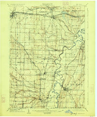
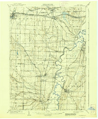
1904 Map of Caledonia
USGS Topo · Published 1925About this map
The Genesee River meanders sharply through this landscape, defining a valley dominated by significant rail infrastructure and scattered agrarian hamlets. The complex transportation network of the early twentieth century is visible in the convergence of lines at Caledonia, where the N. Y. C. and H. R. RR meets the Erie RR and Lehigh Valley. To the south, the industrial influence of salt mining is represented by Retsof and Greigsville, while the village of Geneseo sits prominently above the river's eastern banks. Smaller settlements like Moscow and Cuylerville line the western flats, connected by the Genesee Valley Canal RR. Local geography is further marked by Oatka Creek near Mumford and the family-named crossroads of Teed Corners and Taylor, showing the integration of township life with the era's vital river-and-rail commerce.
Find a feature on this map
61 named features on this map. Tap any name to fly to it.
Don’t see what you’re looking for? This feature index may not catch every label — zoom into the map to look around manually.
Map Details
Editions of this 1904 Caledonia Map
6 editions found
Other maps of this area

1895 · Rochester
USGS Topo · 1:62,500

1897 · Albion
USGS Topo · 1:62,500

1898 · Rochester
USGS Topo · 1:62,500

1899 · Brockport
USGS Topo · 1:62,500

1901 · Honeoye
USGS Topo · 1:62,500

1902 · Wayland
USGS Topo · 1:62,500

1904 · Wayland
USGS Topo · 1:62,500

1904 · Batavia
USGS Topo · 1:62,500

1904 · Caledonia
USGS Topo · 1:62,500

1904 · Honeoye
USGS Topo · 1:62,500