
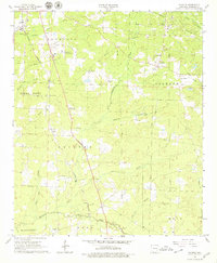
1966 Map of Calhoun
USGS Topo · Published 1967About this map
The Louisiana and North West railroad cuts a diagonal path through this corner of Columbia County, anchoring a mid-century landscape of timber, oil, and small rural communities. Settlements like Brister, Kerlin, and Calhoun dot the secondary roads, while the local economy is clearly defined by the Oil and Gas Field and numerous pipelines branching out from the Tide Water area. This 1960s survey documents a network of country churches and family burial grounds, including Christies Chapel, Macedonia Ch, and Jerusalem Cem, which served the surrounding agricultural districts.
Find a feature on this map
41 named features on this map. Tap any name to fly to it.
Don’t see what you’re looking for? This feature index may not catch every label — zoom into the map to look around manually.
Map Details
Editions of this 1966 Calhoun Map
2 editions found
Other maps of this area

1953 · El Dorado
USGS Topo · 1:250,000

1957 · El Dorado
USGS Topo · 1:250,000

1958 · El Dorado
USGS Topo · 1:250,000

1960 · El Dorado
USGS Topo · 1:250,000

1960 · Walkerville
USGS Topo · 1:24,000

1960 · Macedonia
USGS Topo · 1:24,000

1966 · Village
USGS Topo · 1:24,000

1966 · Spotville
USGS Topo · 1:24,000

1968 · Waldo
USGS Topo · 1:24,000
1968 · Magnolia
USGS Topo · 1:24,000