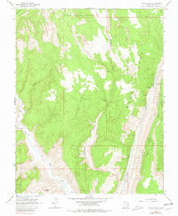
1964 Map of Calico Peak
USGS Topo · Published 1980About this map
Upper Death Valley and Lower Death Valley dominate this corner of southern Utah, where high desert plateaus meet deeply incised drainages. The landscape is defined by the striking geological fold of The Cockscomb, which runs along the eastern edge of the quadrangle, flanked by narrow passes known as Crotch and Cads. These terrain features provided natural, if difficult, corridors for early travel in an area largely devoid of permanent settlements. Water sources are scarce, marked by isolated points like Johnson Hole and various unnamed springs that feed intermittent runs such as Hogeye Creek and Cottonwood Creek. To the south, the Paria River cuts through the territory near Calico Peak, creating a complex network of canyons including Kitchen Canyon and Hackberry Canyon. Distinctive natural landmarks such as Sam Pollock Arch and a Natural Arch near the river highlight the erosion-carved character of this wilderness.
Find a feature on this map
22 named features on this map. Tap any name to fly to it.
Don’t see what you’re looking for? This feature index may not catch every label — zoom into the map to look around manually.
Map Details
Editions of this 1964 Calico Peak Map
4 editions found
Other maps of this area

1886 · Kanab
USGS Topo · 1:250,000

1886 · Escalante
USGS Topo · 1:250,000

1953 · Cedar City
USGS Topo · 1:250,000

1954 · Buckskin Gulch NE
USGS Topo · 1:24,000

1954 · Paria NW
USGS Topo · 1:24,000

1954 · Buckskin Gulch
USGS Topo · 1:62,500

1954 · Paria
USGS Topo · 1:62,500

1955 · The Cockscob SW
USGS Topo · 1:24,000

1956 · Escalante
USGS Topo · 1:250,000

1958 · Cedar City
USGS Topo · 1:250,000