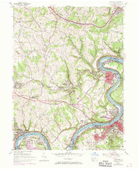
1954 Map of California
USGS Topo · Published 1970About this map
The Monongahela River carves a deep loop through the coal country of Washington and Fayette Counties, anchoring a dense network of riverside industrial towns and upland farming communities. This mid-century landscape is defined by the heavy presence of the Penn Central and Pittsburgh and Lake Erie railroads, which service the region's extraction economy near Vesta No 6. Settlements like California and Coal Center crowd the riverbanks, where the State Teachers College stands as a prominent local institution. Further inland, the path of the National Road cuts across the southern portion of the map, connecting smaller hamlets like Richeyville and Centerville. The terrain is marked by numerous hollows, such as Granville Hollow and Oregon Hollow, where small family churches and cemeteries like Ebenezer Ch and Maple Creek Cem provide critical touchpoints for genealogical research in this historic industrial corridor.
Find a feature on this map
79 named features on this map. Tap any name to fly to it.
Don’t see what you’re looking for? This feature index may not catch every label — zoom into the map to look around manually.
Map Details
Editions of this 1954 California Map
Other maps of this area

1900 · Masontown
USGS Topo · 1:62,500

1901 · Amity
USGS Topo · 1:62,500

1901 · Waynesburg
USGS Topo · 1:62,500

1902 · Brownsville
USGS Topo · 1:62,500

1903 · Masontown
USGS Topo · 1:62,500

1904 · Amity
USGS Topo · 1:62,500

1904 · Waynesburg
USGS Topo · 1:62,500

1906 · Brownsville
USGS Topo · 1:62,500

1931 · Brownsville
USGS Topo · 1:62,500

1931 · Masontown
USGS Topo · 1:62,500