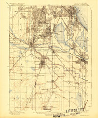
1901 Map of Calumet
USGS Topo · Published 1924About this map
The industrial corridor south of Chicago is defined here by a dense concentration of rail infrastructure and growing manufacturing centers. The planned company town of Pullman sits along the western shore of Calumet Lake, illustrating the era’s intersection of urban planning and industry. To the south and west, the landscape is crisscrossed by an intricate network of railroads, including the Ill. Cent. R. R. and the Chicago Terminal Transfer R. R., which fueled the expansion of settlements like Blue Island, Harvey, and Hammond.
Find a feature on this map
72 named features on this map. Tap any name to fly to it.
Don’t see what you’re looking for? This feature index may not catch every label — zoom into the map to look around manually.
Map Details
Editions of this 1901 Calumet Map
5 editions found

Other maps of this area

1889 · Chicago
USGS Topo · 1:62,500

1890 · Des Plaines
USGS Topo · 1:62,500

1891 · Chicago
USGS Topo · 1:62,500

1891 · Riverside
USGS Topo · 1:62,500

1892 · Calumet
USGS Topo · 1:62,500

1893 · Calumet
USGS Topo · 1:62,500

1893 · Riverside
USGS Topo · 1:62,500

1894 · Des Plaines
USGS Topo · 1:62,500

1900 · Chicago
USGS Topo · 1:62,500

1900 · Des Plaines
USGS Topo · 1:62,500