
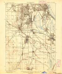
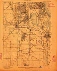
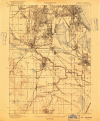
1901 Map of Calumet
USGS Topo · Published 1901This historical map portrays the area of Calumet in 1901, primarily covering Cook County as well as portions of Indiana. Featuring a scale of 1:62500, this map provides a highly detailed snapshot of the terrain, roads, buildings, counties, and historical landmarks in the Calumet region at the time. Published in 1901, it is one of 5 known editions of this map due to revisions or reprints.
Find a feature on this map
73 named features on this map. Tap any name to fly to it.
Don’t see what you’re looking for? This feature index may not catch every label — zoom into the map to look around manually.
Map Details
Editions of this 1901 Calumet Map
5 editions found
Historical Maps of Calumet Township Through Time
30 maps found

1892 Calumet
Cook County, IL

1893 Calumet
Cook County, IL

1900 Calumet
Cook County, IL

1901 Calumet
Cook County, IL

1928 Sag Bridge
Cook County, IL

1929 Calumet Lake
Cook County, IL

1929 Chicago Loop
Cook County, IL

1929 Englewood
Cook County, IL

1929 Jackson Park
Cook County, IL

1953 Calumet Lake
Cook County, IL

1953 Chicago Loop
Cook County, IL

1953 Englewood
Cook County, IL

1953 Jackson Park
Cook County, IL

1953 Sag Bridge
Cook County, IL

1960 Lake Calumet
Cook County, IL

1963 Chicago Loop
Cook County, IL

1963 Englewood
Cook County, IL

1963 Jackson Park
Cook County, IL

1963 Sag Bridge
Cook County, IL

1965 Lake Calumet
Cook County, IL

1991 Lake Calumet
Cook County, IL

1993 Chicago Loop
Cook County, IL

1993 Englewood
Cook County, IL

1993 Jackson Park
Cook County, IL

1993 Sag Bridge
Cook County, IL

1997 Chicago Loop
Cook County, IL

1997 Englewood
Cook County, IL

1997 Lake Calumet
Cook County, IL

1997 Sag Bridge
Cook County, IL

1998 Jackson Park
Cook County, IL
Featured Locations
- Chicago, IL
- Oak Lawn, Worth Township
- Hammond, North Township
- Calumet City, Thornton Township
- Burbank, Stickney Township