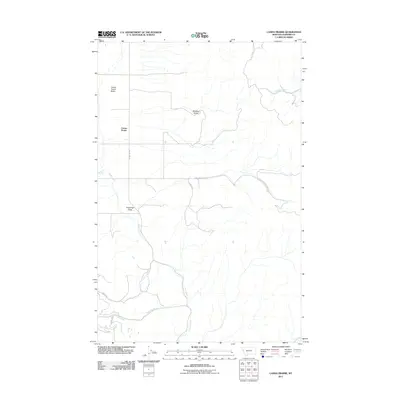
2011 Map of Camas Prairie
USGS Topo · Published 2011About this map
Camas Prairie defines this corner of Sanders County, where the broad open flats of the Camas Prairie Basin meet the descending drainages of the surrounding hills. The landscape is marked by a network of seasonal and perennial waters, including the central Camas Creek, Clear Creek, and the curiously named Whiskey Creek. Human presence in this section of Northwest Montana is centered on ranching and rural transit, anchored by the Melton Ranch in the east. A series of numbered routes such as Camas 1000 and Ferry Crossing Basin 2000 traverse the terrain, tracing the paths between the gulches and the valley floor. The map records the intersection of rugged topography at Coppedge Gulch and Whiskey Gulch with the established agricultural tracts that have long characterized this region.
Find a feature on this map
15 named features on this map. Tap any name to fly to it.
Don’t see what you’re looking for? This feature index may not catch every label — zoom into the map to look around manually.
Map Details
Editions of this 2011 Camas Prairie Map
This is the sole edition of this map. No revisions or reprints were ever made.
Other maps of this area

1920 · Flathead Lake
USGS Topo · 1:125,000

1956 · Wallace
USGS Topo · 1:250,000

1959 · Perma
USGS Topo · 1:62,500

1960 · Wallace
USGS Topo · 1:250,000

1964 · Mc Donald
USGS Topo · 1:24,000

1964 · Melton Ranch
USGS Topo · 1:24,000

1964 · Markle Pass
USGS Topo · 1:24,000

1964 · Hot Springs
USGS Topo · 1:24,000

1965 · Oliver Point
USGS Topo · 1:24,000
1980 · Polson
USGS Topo · 1:100,000