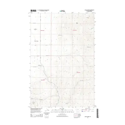
2014 Map of Camas Prairie
USGS Topo · Published 2014About this map
Camas Prairie occupies a distinct geological depression within the Camas Prairie Basin, a landscape defined by sharp drainage gullies and seasonal creek beds in Sanders County. The settlement pattern follows the corridor of MT-382, with a network of local roads such as Webber Ln and Culligan Ln serving the valley floor. The hydrology of the area is centered on the confluence of several named waterways, including Camas Cr, Whiskey Cr, and Clear Cr. High-relief terrain dominates the eastern portion of the map, where the winding Whiskey Trl ascends toward Whiskey Gulch and Big Gulch. To the south, the terrain narrows into the Clear Creek Cyn, illustrating the transition from the open prairie into more confined mountain drainage systems.
Find a feature on this map
23 named features on this map. Tap any name to fly to it.
Don’t see what you’re looking for? This feature index may not catch every label — zoom into the map to look around manually.
Map Details
Editions of this 2014 Camas Prairie Map
This is the sole edition of this map. No revisions or reprints were ever made.
Other maps of this area

1920 · Flathead Lake
USGS Topo · 1:125,000

1956 · Wallace
USGS Topo · 1:250,000

1959 · Perma
USGS Topo · 1:62,500

1960 · Wallace
USGS Topo · 1:250,000

1964 · Mc Donald
USGS Topo · 1:24,000

1964 · Melton Ranch
USGS Topo · 1:24,000

1964 · Markle Pass
USGS Topo · 1:24,000

1964 · Hot Springs
USGS Topo · 1:24,000

1965 · Oliver Point
USGS Topo · 1:24,000
1980 · Polson
USGS Topo · 1:100,000