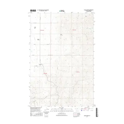
2017 Map of Camas Prairie
USGS Topo · Published 2017About this map
The Camas Prairie Basin of Sanders County, Montana, presents a landscape where the flat valley floor of Camas Prairie meets the rising terrain of the Bitterroot Range. This 2017 survey shows a network of local roads and cattle routes, such as Co Rd 382 and Webber Ln, that serve the agricultural and ranching operations characteristic of this region. The drainage patterns are clearly defined by Camas Cr, Clear Cr, and Whiskey Cr, which flow through the basin and are fed by several prominent ravines including Whiskey Gulch, Big Gulch, and Coppedge Gulch. The Public Land Survey System grids of t20n r24w and t19n r24w provide the framework for the area's rural development. Traces of historical land use appear in labels such as Ferry Crossing Basin 2000, marking the enduring infrastructure of the western Montana interior.
Find a feature on this map
22 named features on this map. Tap any name to fly to it.
Don’t see what you’re looking for? This feature index may not catch every label — zoom into the map to look around manually.
Map Details
Editions of this 2017 Camas Prairie Map
This is the sole edition of this map. No revisions or reprints were ever made.
Other maps of this area

1920 · Flathead Lake
USGS Topo · 1:125,000

1956 · Wallace
USGS Topo · 1:250,000

1959 · Perma
USGS Topo · 1:62,500

1960 · Wallace
USGS Topo · 1:250,000

1964 · Mc Donald
USGS Topo · 1:24,000

1964 · Melton Ranch
USGS Topo · 1:24,000

1964 · Markle Pass
USGS Topo · 1:24,000

1964 · Hot Springs
USGS Topo · 1:24,000

1965 · Oliver Point
USGS Topo · 1:24,000
1980 · Polson
USGS Topo · 1:100,000