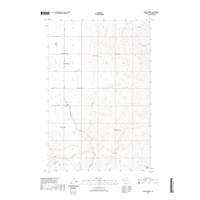
2020 Map of Camas Prairie
USGS Topo · Published 2020About this map
Camas Prairie occupies a distinct topographic position within the Camas Prairie Basin, a high mountain valley defined by a network of drainage systems and narrow gulches. The landscape is characterized by a series of north-south running ridges that divide waterways such as Whiskey Cr and Camas Cr. Local geography is deeply marked by erosion patterns, visible in features like Big Gulch in the northeast and Racehorse Gulch in the southeast corner.
Find a feature on this map
25 named features on this map. Tap any name to fly to it.
Don’t see what you’re looking for? This feature index may not catch every label — zoom into the map to look around manually.
Map Details
Editions of this 2020 Camas Prairie Map
This is the sole edition of this map. No revisions or reprints were ever made.
Other maps of this area

1920 · Flathead Lake
USGS Topo · 1:125,000

1956 · Wallace
USGS Topo · 1:250,000

1959 · Perma
USGS Topo · 1:62,500

1960 · Wallace
USGS Topo · 1:250,000

1964 · Mc Donald
USGS Topo · 1:24,000

1964 · Melton Ranch
USGS Topo · 1:24,000

1964 · Markle Pass
USGS Topo · 1:24,000

1964 · Hot Springs
USGS Topo · 1:24,000

1965 · Oliver Point
USGS Topo · 1:24,000
1980 · Polson
USGS Topo · 1:100,000