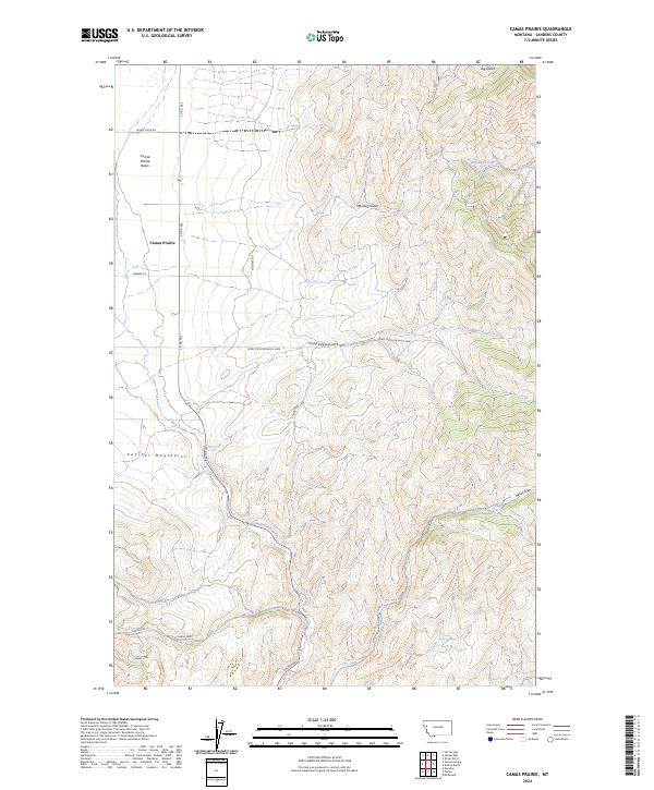
2024 Map of Camas Prairie
USGS Topo · Published 2024About this map
Camas Prairie Basin forms a distinct topographical bowl in this part of Sanders County, where the settlement of Camas Prairie serves as the primary landmark. The landscape is defined by the sharp transition between the open basin floor and the rising slopes of the Cabinet Mountains to the west. This modern survey tracks the intricate drainage network of the area, including Whiskey Creek and Camas Creek, along with several notable incisions such as Whiskey Gulch and Coppedge Gulch. The road network, including family-named routes like Fitchett Rd and utility access ways like Ferry Crossing Basin 2000, reveals the contemporary land management patterns. Local history and genealogy researchers can trace the reach of the prairie relative to the surrounding high country and various draws like Wilcox Draw.
Find a feature on this map
21 named features on this map. Tap any name to fly to it.
Don’t see what you’re looking for? This feature index may not catch every label — zoom into the map to look around manually.
Map Details
Editions of this 2024 Camas Prairie Map
This is the sole edition of this map. No revisions or reprints were ever made.
Other maps of this area

1920 · Flathead Lake
USGS Topo · 1:125,000

1956 · Wallace
USGS Topo · 1:250,000

1959 · Perma
USGS Topo · 1:62,500

1960 · Wallace
USGS Topo · 1:250,000

1964 · Mc Donald
USGS Topo · 1:24,000

1964 · Melton Ranch
USGS Topo · 1:24,000

1964 · Markle Pass
USGS Topo · 1:24,000

1964 · Hot Springs
USGS Topo · 1:24,000

1965 · Oliver Point
USGS Topo · 1:24,000
1980 · Polson
USGS Topo · 1:100,000