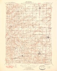
1948 Map of Camp Point
USGS Topo · Published 1948About this map
The agricultural landscape of Western Illinois is defined here by a dense grid of rural schools and family-linked landmarks just after the post-war era. Significant rail activity centers on Camp Point, where the Chicago Burlington and Quincy and Wabash lines intersect, supporting the local grain and trade economy of settlements like Golden, Paloma, and Coatsburg. The map reveals a highly decentralized educational network, with one-room schoolhouses such as Prairie View Sch, Mission Ridge Sch, and Rocky Hill Sch spaced consistently across the townships of Alban S, Houston, and Concord. Genealogy researchers will find substantial detail in the numerous burial sites, including the Bowen Cem, Friedhof Cem, and the secluded Ebenezer Cem. From the Town Hall in Houston to the County Farm near the southern border, the map documents the civic and social infrastructure of a mid-century farming community.
Find a feature on this map
79 named features on this map. Tap any name to fly to it.
Don’t see what you’re looking for? This feature index may not catch every label — zoom into the map to look around manually.
Map Details
Editions of this 1948 Camp Point Map
2 editions found

Other maps of this area

1913 · Colchester
USGS Topo · 1:62,500

1925 · Quincy
USGS Topo · 1:62,500

1925 · Liberty
USGS Topo · 1:62,500

1926 · Mt Sterling
USGS Topo · 1:62,500

1927 · Liberty
USGS Topo · 1:62,500

1929 · Mt Sterling
USGS Topo · 1:62,500

1933 · Carthage
USGS Topo · 1:62,500

1936 · Keokuk
USGS Topo · 1:62,500

1937 · Carthage
USGS Topo · 1:62,500

1944 · Quincy
USGS Topo · 1:62,500