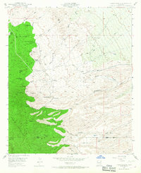
1948 Map of Campo Bonito
USGS Topo · Published 1967About this map
The Santa Catalina Mts dominate this mid-century survey of the high desert, revealing a landscape defined by cattle ranching and hard-rock mining. Prominent family-owned holdings like Kannally Ranch and the American Flag Ranch anchor the northern reaches, while the terrain transitions into the protected slopes of the Coronado National Forest. This era shows a cluster of named workings including the Highjinks Mine, Southern Belle Mine, and Old Maudina Mine, marking the region's enduring mining heritage. Navigation through this dry country relied on the Mt Lemmon Road and tracks like Smelter Road, which followed the natural contours of deep drainages such as Peppersauce Wash and Stratton Canyon. The survey captures the interface of the Pinal Co and Pima Co line just south of Rice Peak, where the high-altitude topography drops into the broad washes and ranch lands below.
Find a feature on this map
40 named features on this map. Tap any name to fly to it.
Don’t see what you’re looking for? This feature index may not catch every label — zoom into the map to look around manually.
Map Details
Editions of this 1948 Campo Bonito Map
5 editions found
Other maps of this area

1904 · Tucson
USGS Topo · 1:125,000

1905 · Tucson
USGS Topo · 1:125,000

1911 · Winkelman
USGS Topo · 1:125,000

1913 · Winkelman
USGS Topo · 1:125,000

1948 · Clark Ranch
USGS Topo · 1:24,000

1948 · Mammoth
USGS Topo · 1:62,500

1948 · Mammoth
USGS Topo · 1:24,000

1948 · Campo Bonito
USGS Topo · 1:24,000

1948 · Peppersauce Wash
USGS Topo · 1:24,000

1949 · Clark Ranch
USGS Topo · 1:24,000