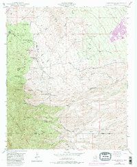
1948 Map of Campo Bonito
USGS Topo · Published 1982About this map
The rugged landscape of the Coronado National Forest defines this region of Pinal County, where mining and ranching legacy are etched into the desert terrain. In the vicinity of Campo Bonito, several historic mining operations such as the Highlinks Mine, Bonito Mine, and Southern Belle Mine reflect the era's mineral pursuits, supported by a central Smelter and the Old Maudina Mine. The map reveals a distribution of early homesteads and cattle operations, including the Kannally Ranch, Cherry Valley Ranch, and the C O D Ranch. To the northeast, the development of San Manuel begins to take shape against the backdrop of Big Wash. Significant topographical markers like Rice Peak and American Flag Hill rise above a network of seasonal drainages, including Peppersauce Wash and Cottonwood Wash, illustrating the difficult geography that early settlers and miners navigated along the Mt Lemmon Road.
Find a feature on this map
29 named features on this map. Tap any name to fly to it.
Don’t see what you’re looking for? This feature index may not catch every label — zoom into the map to look around manually.
Map Details
Editions of this 1948 Campo Bonito Map
5 editions found
Other maps of this area

1904 · Tucson
USGS Topo · 1:125,000

1905 · Tucson
USGS Topo · 1:125,000

1911 · Winkelman
USGS Topo · 1:125,000

1913 · Winkelman
USGS Topo · 1:125,000

1948 · Clark Ranch
USGS Topo · 1:24,000

1948 · Mammoth
USGS Topo · 1:62,500

1948 · Mammoth
USGS Topo · 1:24,000

1948 · Campo Bonito
USGS Topo · 1:24,000

1948 · Peppersauce Wash
USGS Topo · 1:24,000

1949 · Clark Ranch
USGS Topo · 1:24,000