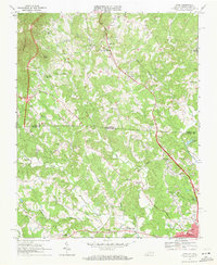
1968 Map of Cana
USGS Topo · Published 1971About this map
The Virginia-North Carolina border bisects this 1968 landscape, marking the transition between Carroll County and Surry County. The settlement of Cana serves as a central hub along the highway corridor, while the southern edge of the sheet reaches the community of Toast. This era is defined by a dense network of country schools and rural congregations, including Sandy Ridge School, St. Paul's Junior High School, and churches such as Rocky Ford Ch and New Bethel Ch. The terrain is shaped by the descent of the Blue Ridge, with prominent peaks like Sugarloaf and Wheeler Knob overlooking the headwaters of Pauls Creek and Stewarts Creek. Notable landmarks of the period include the Golf Course and several localized water bodies like Greenhill Lake and City Lake, reflecting the region's agricultural and developing residential character during the late 1960s.
Find a feature on this map
55 named features on this map. Tap any name to fly to it.
Don’t see what you’re looking for? This feature index may not catch every label — zoom into the map to look around manually.
Map Details
Editions of this 1968 Cana Map
Other maps of this area

1889 · Hillsville
USGS Topo · 1:125,000

1891 · Yadkinville
USGS Topo · 1:125,000

1892 · Hillsville
USGS Topo · 1:125,000

1893 · Yadkinville
USGS Topo · 1:125,000

1896 · Hillsville
USGS Topo · 1:125,000

1931 · Galax
USGS Topo · 1:48,000

1933 · Galax
USGS Topo · 1:62,500

1953 · Winston-Salem
USGS Topo · 1:250,000

1955 · Winston-Salem
USGS Topo · 1:250,000

1957 · Mount Airy
USGS Topo · 1:62,500