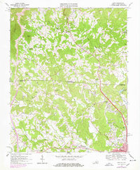
1968 Map of Cana
USGS Topo · Published 1978About this map
Cana sits at the heart of this landscape where the Blue Ridge foothills meet the Piedmont along the Virginia North Carolina border. The settlement pattern here is defined by small agricultural communities clustered around crossroads and numerous rural sanctuaries, such as Sandy Ridge Ch and New Bethel Ch. The terrain transitions from the high elevations of Sugarloaf and Wheeler Knob in the northwest down toward the rolling creek valleys of Pauls Creek and Stewarts Creek.
Find a feature on this map
57 named features on this map. Tap any name to fly to it.
Don’t see what you’re looking for? This feature index may not catch every label — zoom into the map to look around manually.
Map Details
Editions of this 1968 Cana Map
Other maps of this area

1889 · Hillsville
USGS Topo · 1:125,000

1891 · Yadkinville
USGS Topo · 1:125,000

1892 · Hillsville
USGS Topo · 1:125,000

1893 · Yadkinville
USGS Topo · 1:125,000

1896 · Hillsville
USGS Topo · 1:125,000

1931 · Galax
USGS Topo · 1:48,000

1933 · Galax
USGS Topo · 1:62,500

1953 · Winston-Salem
USGS Topo · 1:250,000

1955 · Winston-Salem
USGS Topo · 1:250,000

1957 · Mount Airy
USGS Topo · 1:62,500