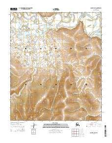
2014 Map of Candle A-5 SE
USGS Topo · Published 2014About this map
Dime Landing sits along a sweeping bend of the Koyuk River, serving as a vital point of navigation in this interior Alaskan landscape. The terrain is defined by the water networks of Kenwood Cr, Dime Cr, and Alameda Cr, which carve through the rising elevations of the Seward Peninsula. A single terrestrial artery, the Koyuk Hotsprings Road, provides the primary overland connection through the township grids of the region. This 2014 survey documents the enduring geography of the area, where the river remains the central feature for both transport and subsistence. The map illustrates how small-scale settlements like Dime Landing are positioned at the confluence of hydrological and topographical boundaries, reflecting the logistical realities of life in the Alaskan bush.
Find a feature on this map
13 named features on this map. Tap any name to fly to it.
Don’t see what you’re looking for? This feature index may not catch every label — zoom into the map to look around manually.
Map Details
Editions of this 2014 Candle A-5 SE Map
This is the sole edition of this map. No revisions or reprints were ever made.
Other maps of this area

1948 · Norton Bay
USGS Topo · 1:250,000

1950 · Norton Bay D-5
USGS Topo · 1:63,360

1950 · Candle A-5
USGS Topo · 1:63,360

1950 · Norton Bay D-4
USGS Topo · 1:63,360

1951 · Candle
USGS Topo · 1:250,000

1951 · Norton Bay
USGS Topo · 1:250,000

1955 · Candle
USGS Topo · 1:250,000

1955 · Norton Bay
USGS Topo · 1:250,000
1955 · Candle A-4
USGS Topo · 1:63,360

1964 · Candle
USGS Topo · 1:250,000