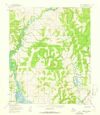
1955 Map of Candle A-4
USGS Topo · Published 1966About this map
The Koyuk River and the Inglutalik River dominate this mid-century topographic study of the Seward Peninsula interior. Based on 1955 aerial photography, the map illustrates a landscape shaped by vast drainage systems and seasonal waterways. The complex meandering path of the Koyuk River in the west contrasts with the braided channels of the Inglutalik River in the southeast, revealing the hydrological patterns of the Alaskan tundra before modern development. Other significant water features include the Tipooktulearuk River and the East Fork, along with the localized label of Alameda in the southwestern quadrant. This survey, which includes land lines predetermined by the Bureau of Land Management, captures the region in a strictly natural state, devoid of established roads or permanent settlements at the time of the field annotation.
Find a feature on this map
5 named features on this map. Tap any name to fly to it.
Don’t see what you’re looking for? This feature index may not catch every label — zoom into the map to look around manually.
Map Details
Editions of this 1955 Candle A-4 Map
2 editions found
Other maps of this area

1948 · Norton Bay
USGS Topo · 1:250,000

1950 · Norton Bay D-5
USGS Topo · 1:63,360

1950 · Candle B-5
USGS Topo · 1:63,360

1950 · Candle A-5
USGS Topo · 1:63,360

1950 · Norton Bay D-4
USGS Topo · 1:63,360

1950 · Norton Bay D-3
USGS Topo · 1:63,360

1951 · Candle
USGS Topo · 1:250,000

1951 · Norton Bay
USGS Topo · 1:250,000

1955 · Candle
USGS Topo · 1:250,000

1955 · Norton Bay
USGS Topo · 1:250,000