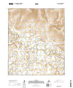
2017 Map of Candle A-6 NE
USGS Topo · Published 2017About this map
The Koyuk River dominates the central terrain of this Nome Census Area quadrant, its meandering path carving through a landscape defined by complex hydrology. In this remote Alaskan environment, the river system exhibits classic oxbow formations and numerous smaller water bodies, reflecting a dynamic flood plain. The southern portion of the sheet is drained by Salmon Creek, while the higher elevations are marked by the townships of t3s r15w and t3s r14w in the north, transitioning to t4s r15w and t4s r14w in the south. This 2017 survey by the U.S. Geological Survey captures a wilderness area devoid of modern infrastructure, showing the natural drainage patterns of the Seward Peninsula before significant human footprint or road development reached these specific sections.
Find a feature on this map
6 named features on this map. Tap any name to fly to it.
Don’t see what you’re looking for? This feature index may not catch every label — zoom into the map to look around manually.
Map Details
Editions of this 2017 Candle A-6 NE Map
This is the sole edition of this map. No revisions or reprints were ever made.
Other maps of this area

1950 · Candle A-6
USGS Topo · 1:63,360

1950 · Candle B-5
USGS Topo · 1:63,360

1950 · Candle A-5
USGS Topo · 1:63,360

1950 · Candle B-6
USGS Topo · 1:63,360

1951 · Candle
USGS Topo · 1:250,000

1955 · Candle
USGS Topo · 1:250,000

1964 · Candle
USGS Topo · 1:250,000
2014 · Candle A-5 SW
USGS Topo · 1:25,000
2014 · Candle A-5 NW
USGS Topo · 1:25,000
2014 · Candle B-5 SW
USGS Topo · 1:25,000