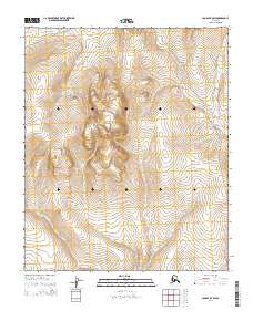
2014 Map of Candle B-5 SW
USGS Topo · Published 2014About this map
Continental Divide crests through this remote stretch of the Seward Peninsula, forming a natural spine between the drainages of the north and south. The landscape is dominated by the prominent rise of Bear Mountain, which serves as a central landmark amidst a complex network of high-altitude waterways. Several significant streams originate or flow through this terrain, including Sweepstakes Cr and Wilson Cr, which carve paths through the undulating topography. Human presence is marked primarily by the Koyuk Hotsprings Road, which traces a route along the eastern edge of the quadrangle. This path provides a rare corridor of transit through a region otherwise defined by its raw drainage systems, such as Granite Cr and Spring Cr, illustrating the challenges of navigation in this portion of the Nome census area.
Find a feature on this map
13 named features on this map. Tap any name to fly to it.
Don’t see what you’re looking for? This feature index may not catch every label — zoom into the map to look around manually.
Map Details
Editions of this 2014 Candle B-5 SW Map
This is the sole edition of this map. No revisions or reprints were ever made.
Other maps of this area

1950 · Candle A-6
USGS Topo · 1:63,360

1950 · Candle B-5
USGS Topo · 1:63,360

1950 · Candle A-5
USGS Topo · 1:63,360

1950 · Candle B-6
USGS Topo · 1:63,360

1951 · Candle
USGS Topo · 1:250,000

1955 · Candle
USGS Topo · 1:250,000

1964 · Candle
USGS Topo · 1:250,000
2014 · Candle A-5 NE
USGS Topo · 1:25,000
2014 · Candle B-5 NW
USGS Topo · 1:25,000
2014 · Candle B-6 NE
USGS Topo · 1:25,000