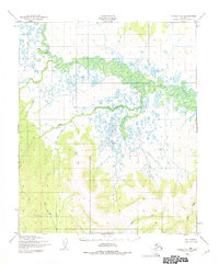
1950 Map of Candle A-6
USGS Topo · Published 1975About this map
The Koyuk River winds across the northern half of this landscape, its complex meanders and side channels defining a broad alluvial plain characterized by numerous small lakes and marshy ground. Topographic data captured by the Corps of Engineers in 1949 and 1950 reveals a transition from these low-lying wetlands to the elevated terrain of the south, where the drainage divide separates several distinct water systems. The Kwik River and its tributaries, including Kelly Creek and Quartz Creek, flow southward away from the main valley. The map documents an era of unsurveyed wilderness within the Kateel River Meridian, showing the natural geography of the Seward Peninsula before significant modern development. Named watercourses like Salmon Creek and Copper Creek serve as the primary landmarks in a region defined by its hydrography rather than human settlements.
Find a feature on this map
14 named features on this map. Tap any name to fly to it.
Don’t see what you’re looking for? This feature index may not catch every label — zoom into the map to look around manually.
Map Details
Editions of this 1950 Candle A-6 Map
2 editions found
Other maps of this area

1948 · Norton Bay
USGS Topo · 1:250,000

1950 · Bendeleben B-1
USGS Topo · 1:63,360

1950 · Bendeleben A-1
USGS Topo · 1:63,360

1950 · Norton Bay D-6
USGS Topo · 1:63,360

1950 · Bendeleben
USGS Topo · 1:250,000

1950 · Norton Bay D-5
USGS Topo · 1:63,360

1950 · Solomon D-1
USGS Topo · 1:63,360

1950 · Solomon
USGS Topo · 1:250,000

1950 · Candle A-6
USGS Topo · 1:63,360

1950 · Candle B-5
USGS Topo · 1:63,360