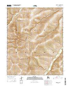
2015 Map of Candle C-1 SE
USGS Topo · Published 2015About this map
The interior wilderness of Alaska is defined by the Public Land Survey System in this 2015 study, which outlines the intersections of T3n R3w, T3n R2w, and several other township boundaries. This specific quadrangle covers a landscape where the lack of human settlements or named water bodies is its most defining characteristic, represented instead by the precise grid of the T2n R3w and T2n R2w sections. The absence of roads or structures in this region emphasizes the isolation of the Alaskan bush during the early 21st century. Researchers focused on the legal geography of the state can trace the exact lines of T1n R3w and T1n R2w as they were delineated for land management and mapping purposes.
Find a feature on this map
6 named features on this map. Tap any name to fly to it.
Don’t see what you’re looking for? This feature index may not catch every label — zoom into the map to look around manually.
Map Details
Editions of this 2015 Candle C-1 SE Map
This is the sole edition of this map. No revisions or reprints were ever made.
Other maps of this area

1951 · Candle
USGS Topo · 1:250,000

1951 · Kateel River
USGS Topo · 1:250,000

1954 · Candle C-1
USGS Topo · 1:63,360

1954 · Candle B-1
USGS Topo · 1:63,360

1954 · Kateel River C-6
USGS Topo · 1:63,360
1955 · Kateel River B-6
USGS Topo · 1:63,360

1955 · Kateel River
USGS Topo · 1:250,000

1955 · Candle
USGS Topo · 1:250,000

1964 · Candle
USGS Topo · 1:250,000
2015 · Kateel River C-6 SW
USGS Topo · 1:25,000