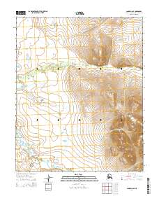
2014 Map of Candle C-6 SE
USGS Topo · Published 2014About this map
Weather Ridge dominates the eastern elevation of this Northwest Arctic landscape, serving as a prominent topographic divide. The drainages of Coal Cr and Quartz Cr flow westward through the central and northern sections of the map, carving distinct pathways through the undulating terrain toward the Kiwalik River in the southwest. The systematic division of the land into townships like t2n r14w and t1n r15w reflects the administrative organization of this Alaskan interior during the early 21st century. The map illustrates a largely natural drainage network, where the shifting courses of these interior waterways reveal the slow geological processes of the Seward Peninsula region.
Find a feature on this map
10 named features on this map. Tap any name to fly to it.
Don’t see what you’re looking for? This feature index may not catch every label — zoom into the map to look around manually.
Map Details
Editions of this 2014 Candle C-6 SE Map
This is the sole edition of this map. No revisions or reprints were ever made.
Other maps of this area

1950 · Candle C-5
USGS Topo · 1:63,360

1950 · Candle B-5
USGS Topo · 1:63,360

1950 · Candle B-6
USGS Topo · 1:63,360

1950 · Candle C-6
USGS Topo · 1:63,360

1951 · Candle
USGS Topo · 1:250,000

1955 · Candle
USGS Topo · 1:250,000

1964 · Candle
USGS Topo · 1:250,000
2014 · Candle C-5 NW
USGS Topo · 1:25,000
2014 · Candle C-6 NW
USGS Topo · 1:25,000
2014 · Candle C-5 SW
USGS Topo · 1:25,000