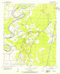
1952 Map of Canfield
USGS Topo · Published 1953About this map
The Red River creates a meandering border between Miller and Lafayette counties, carving out a landscape defined by oxbows and swampy lowlands. During the early 1950s, this region was characterized by the complex interaction of the river and a system of levees, which created numerous cut-offs and secluded water bodies such as Dillard Bend and Dixon Bend. These bends often isolated pockets of land, resulting in a series of lakes including Fish Lake, Goose Lake, and Copeland Lake.
Find a feature on this map
25 named features on this map. Tap any name to fly to it.
Don’t see what you’re looking for? This feature index may not catch every label — zoom into the map to look around manually.
Map Details
Editions of this 1952 Canfield Map
4 editions found
Other maps of this area

1952 · Doddridge SE
USGS Topo · 1:24,000

1952 · Bradley
USGS Topo · 1:24,000

1952 · Garland
USGS Topo · 1:24,000

1952 · Fouke SE
USGS Topo · 1:24,000

1952 · Bradley NE
USGS Topo · 1:24,000

1952 · Doddridge NE
USGS Topo · 1:24,000

1952 · Canfield
USGS Topo · 1:24,000

1952 · Lewisville
USGS Topo · 1:24,000

1952 · Bradley SE
USGS Topo · 1:24,000

1953 · El Dorado
USGS Topo · 1:250,000